Layout Plans
MY MODEL RAILROAD LAYOUT FEATURES A MULTI-LEVEL DESIGN which varies from one level in some areas to four levels in other areas as the tracks circle the room. Using a multi-level design allowed me to get the most trackage in my 20-foot by 20-foot space. The lowest level is 46" above the floor and the logging area, serviced by an operating incline, is 77" above the floor. I believe that my layout is one of the very early examples of a true multi-level layout.
My layout design follows the prototype YVRR as closely as possible, given the space available. This "bird's eye" view of the prototype railroad is from a 1929 YV brochure:

USGS maps, historical aerial photos, actual YV route maps from the California State Archives, and Sanborn Insurance Company maps were used to develop the yard configurations, resulting in yard arrangements on the layout which closely follow the prototype. Stations along the layout are in prototypical order. When viewing the layout, you are always looking north, with west to the left and east to the right. (The prototype YV actually left Merced heading north but turned east near Snelling. However, timetables always refer to only eastbound and westbound trains and any train leaving Merced is eastbound.)
The following layout plans are courtesy Model Railroader magazine and were part of an article on completing my layout in the 2013 issue of Great Model Railroads. Here is an Adobe Acrobat file with the same plans but to a larger scale.
Lower Level

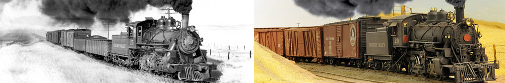
The doors to the layout room are on the top of this plan. To the left, as you enter the room, is the interchange between the Yosemite Valley Railroad and the Southern Pacific Railroad in Merced. This area can seem confusing when looking just at the layout plans since there are two levels above this interchange area. El Portal, which is on the middle level, is to the right. This photo might help:

Looking at the plan again, from the SP Interchange, tracks cross the duck-under (under the waters of Exchequer Reservoir) and enter a reversing loop under the peninsula. The reversing loop is not used during regular operating sessions but only for Open House events. At the right end of the duck-under (still under the lake) is a turnout. The left leg connects to the SP interchange while the right leg leads to the Merced yards. A freight train which has picked up or set out cars at the SP Interchange can return to the YV Merced yards by crossing the duck-under, passing around the reversing loop, and then taking the right-hand track at this turnout.
The reversing loop under the peninsula also provides a location for staging and I did provide one passing track for this purpose with the idea of adding more later. Including staging (a lot of staging) was a constant theme of layout design articles when I was designing my layout, hence my decision to include at least one staging track. In fact, the typical recommendation was to figure out how much staging you needed and then double it.
However, staging really isn’t appropriate for my type of operation which is more typical of a branch line than a "bridge" route. Rather than modeling a railroad where most trains are through trains, the Yosemite Valley Railroad simply ran from interchanges with the SP and ATSF in Merced and dead-ended at El Portal at the boundary of Yosemite National Park, 77 miles east. During operating sessions, all trains begin at either Merced or El Portal (quite similar to the prototype YV) and run the length of the line before tying up. The single "staging" track has therefore never been used for staging.
Merced was the site of the railroad’s main yards and includes the station/general office, roundhouse, turntable, and all of the other buildings in the Merced yards. The prototype had a wye here which extended north of the yard to turn passenger trains although I didn’t duplicate it. With this exception, the layout design follows the prototype fairly closely except for the need to compress the trackage lengthwise.
From Merced, the mainline crosses the ATSF mainline (protected by an working interlocking plant) and, after crossing over several creeks, passes a spur leading to the Yosemite Portland Cement Company plant. On the prototype, this was a mile-long spur servicing a very large cement-producing plant. The YV delivered limestone (the main ingredient in Portland cement) from a quarry at Emory (modeled on the upper level) to this plant using ex-Great Northern 22’ hopper cars (called "rock cars" on the YV). Rather than attempt to build the cement plant, I included just a short spur here which still allows the switching operations to be duplicated.
Beyond the YPCo. spur, tracks cross the Merced River on Bridge 13A, pass through the river-bottom area around Hopeton and enter Merced Falls, site of Yosemite Sugar Pine Lumber Company lumber mill, box factory, planing mill, and shipping dock. Logs were delivered by the YV to Merced Falls from Incline (also modeled on the upper level). The YV was therefore relatively unique in that it picked up raw materials (logs and limestone) from two on-line locations and delivered them to on-line plants for processing. The finished products from these operations (lumber and bagged cement) were also picked up by the YV and delivered to either the SP or ATSF interchanges in Merced. (I didn’t model the ATSF interchange).
Upon leaving Merced Falls, the YV mainline begins the 2.3% climb from the lower level (at generally 46" from the floor) to the upper level (generally at 60" from the floor). It soon enters Tunnel 1, one of four concrete-lined tunnels and five steel bridges built as part of a track relocation project in the early 1920s. That relocation was necessitated by the construction of Exchequer Dam on the Merced River upstream of Merced Falls. (See the web page on History of the YV for more information.) A one-turn helix is hidden in the peninsula inside the tunnel, picking up 8" in elevation in the process. After exiting from Tunnel 4, the tracks level off to cross Bridge 39B, a 110-foot-long steel deck bridge over a portion of McClure Reservoir. (The plan and the lead photo show an earlier truss bridge originally spanning the lake but it was accidentally damaged during an Open House and replaced with the current deck bridge.)
Upon passing over Exchequer Reservoir, the tracks duck behind the Merced yards and continue the climb to the middle level.
Middle Level
The tracks emerge just before crossing Bridge 47A over the Merced River, known on the YV as the Bagby Bridge, at the bottom of the plan below for the Middle Level.

After crossing the river, tracks enter the small community of Bagby and cross Highway 49 (well-known to visitors touring the the Mother Lode gold country along the Sierra Nevada foothills). The four modeled buildings plus the YV station and water tank comprise just about the entire town here.
Bagby was at milepost 47.7 while Briceburg was at milepost 60.8, a distance of 13 miles. This section of the railroad route is accessible only by foot or white water rafting and I didn't have the opportunity to visit it before designing my layout. Lacking good information on this section, I choose to not model it.
Beyond Bagby, the tracks continue to follow the Merced River (on the aisle side of the middle level) to Emory (on the left wall in the plan). Emory was site of the Yosemite Portland Cement limestone quarry and a 2,100-foot-long incline. The incline ran between the quarry/crusher at the top of the incline and the 275-ton storage bunker next to the tracks. The incline and quarry are hinted at on the backdrop here.

Around the corner is Incline on the end of the peninsula which was the lower end of the 8,700-foot-long logging incline coming down from Trumbell Peak. That incline gave access to the timber north of Trumbell Peak harvested by the Yosemite Sugar Pine Lumber Company. The incline on the layout is animated although it is not actually used to move loaded log cars down from the woods to Incline.

Continuing past Incline, the mainline crosses the duck-under section again and passes the water tank at Moss Canyon before circling behind Merced to arrive at the wye at Moss Canyon. Note that this trackage is not a reversing loop but is simply a way to have trains arrive in El Portal oriented the same direction as the prototype. On the prototype, freight trains ran straight into El Portal while passenger trains were turned on the wye and backed the remaining 2.5 miles to El Portal; I follow the same pattern during operations on the layout.
There is a slight grade from Incline to Moss Canyon (this was the steepest grade on the prototype) which results in the Moss Canyon wye being 62" from the floor. El Portal is at the same level as the wye but a step-up from the duck-under to the floor in front of El Portal makes the rail height at El Portal only 54-1/2" above the floor.
Upper Level

The upper level models the Camp 17 area. This area is directly above Moss Canyon on the middle level and represents the logging areas near present-day Highway 120. This scene is fully functional but, at 77" from the floor, can only be seen or operated by standing on a step stool. I had originally envisioned an operator would be work this section, ferrying loaded log cars out to the top of the incline and empties back to the camp using one of the lumber company Shays. However, I eventually gave up on this idea and the scene is now static.
Layout Summary
Size - 20 x 20 feet
Time Period - August 1939
Mainline run - 235 feet
Minimum radius - 22" with spiral easements
Minimum turnout - No. 5
Maximum grade - 2.3%
Track - Handlaid Codes 55, 70, and 83 (SP and ATSF mainlines and YV/ATSF diamond only)